Selaus nimekkeen mukaan kokoelmassa 1. Suomi osana Eurooppaa, Ruotsia, Venäjää
Viitteet 1-20 / 133
-
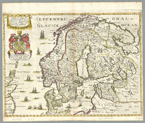
A generall mapp of Scandinavia, where are ye estates and kingdomes of Danemark, Norway and Sweden by Monsieur Sanson
(London: Richard Blome, [1693?], 1693) -
A generall mappe of Scandinavia, where are the estates and kingdomes of Danemark, Norway, and Sweden
(London: Richard Blome, [1670], 1670) -
A new & accurate map of Sweden: collected from the latest improvemts. and adjusted by the most authentic astronl. observations
([London]: [William Innys ... et al.], [1747], 1747) -
A new and exact map of Sweden and Norway corrected from the best observations communicated to the Royal Society at London & the Royal Academy at Paris &c.
(Made and sold by George Willdey at the corner house in Ludgate street next S:t. Pauls Church London: [s.n.], [1717?], 1717) -
A new map of Denmark and Sweden: according to ye newest and most exact observations
([London]: printed for H. Moll over against Devereux Court without Temple Bar in the Strand Iohn Bowles at the Black Horse in Cornhill, Thomas Bowles print & mapseller next to the Chapter House in St. Pauls Church yard and by Philip Overton map & printseller near S. Dunstans Church Fleetstreet, 1712, 1712) -
A new map of Denmark, Norway, Sweden & Moscovy, shewing their present general divisions, cheif, cities or towns, rivers, mountains, &c.: dedicated to his highness William Duke of Glocester
([Oxford]: [printed at the Theater, An.Dom. MDCCI], 1701?, 1701) -
A new map of Europe from the latest observations: inscrib'd to the hono.ble Samuel Molyneux esq. secretary to his R. H. the Prince
([London]: [printed for Daniel Browne etc.], 1721, 1721) -
A new map of Scandinavia: containing ye kingdoms of Sweden, Denmark & Norway
([London]: [John Senex], ca. 1720, 1720) -
A new map of Sweden and Norway
(London: James Wyld, ca. 1840, 1840) -
A new map of Sweden, Denmark and Norway, from the latest authorities
(London: J. Cary engraver & map seller no. 181 Strand, Aug. 1st 1801, 1801) -
A new map of the Baltick & c.: shewing all the dominions about it with ye great or post roads and principal cross-roads
([London]: [Herman Moll], ca. 1720, 1720) -
A new map of the Northern States containing the Kingdoms of Sweden, Denmark, and Norway; with the western parts of Russia, Livonia, Courland & ca.
(London: printed for Robert Sayer, 1790, 1790) -
A new map of the Northern States containing the Kingdoms of Sweden, Denmark, and Norway; with the western parts of Russia, Livonia, Courland & ca.
(London: printed for Robert Sayer, 1788, 1788) -
An accurate map of Sweden, Denmark, and Norway, from the best authorities by Thos. Bowen
([London]: [s.n.], [17--], 1770) -
Baltia, quae et Scandia, Finningia, Cimbrica Chersonesu & c.
([Paris]: [Jean le Clere], 1703, 1703) -
Baltia, quae et Scandia, Finningia, Cimbrica Chersonesu & c.
([Paris]: [Sanson?], 1654, 1654) -
Bowles's New Pocket Map of the Kingdoms of Sweden and Norway, from the maps of Homan, published at Nuremberg
(No. 69 in St. Pauls Church Yard London: printed for the proprietor Carington Bowles, [1779?], 1779) -
Carte de l'Empire des Russies en Europe: partie septentrionale
(A Paris: chez Bourgoin Graveur rue de la Harpe vis-a-vis le Passage des Jacobins à côté du Caffé de Condé, 1765, 1765) -
Carte de la partie européenne de l'empire de Russie, avec l'indication des chemins de poste, ainsi que des douanes frontières et de la repartition actuelle en gouvernements et districts /
(St. Peterbourg :, Depôt imperial des cartes, 1809, 1809)


