Haku
Viitteet 1-10 / 14

Carte de la Mer Baltique contenant les bancs, isles et costes comprises entre L'Isle de Zelande et l'Extremité du Golfe de Finlande
(A Paris: [H. Jaillot], 1693, 1693)


A correct chart of the Baltick or East Sea: from ye Sound to Petersburg : from the latest and best observations for Mr. Tindal's Continuation of Mr. Rapin's History
([London]: [John & Paul Knapton], 1744, 1744)

Groote Pas-Caart van de Oost-Zee
(Coppenhage: Hans Bentse, 1700, 1700)

Carte réduite de la mer Baltique
([Paris]: [Froullé], 1785, 1785)


Mare Balticum. Amstelodami, Apud. F. de Wit. ; Nieuwe pascaert van de Oost Zee t Amsterdam Gedruckt by F. de Wit
([Amsterdam] : [F. de Wit], 1686)
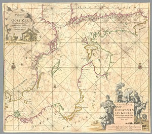
Paskaart van de Oost Zee: verthoonende al de gelegentheyt tusschen Rostock, en Wyborg : naaukeurig opgestelt : met privilegie voor 15 Iaare
('t Amsterdam: by Johannis van Keulen Boekverkoper aan de Nieuwenbrugh Inde Gekroonde Loots-man, 1694, 1694)

Pascaerte vande Oost Zee: van't Eylandt Ruygen ofte Bornholm tot aen Wyborgh
('t Amsterdam: by Iohannis van Loo en Johannes van Waesberge, 1666?, 1666)
